.jpg)
.jpg)
.jpg)
Beschreibung
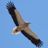
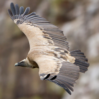
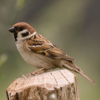
The Valle de Allín is ideal for birdwatching, combining diverse habitats: plateaus, rocky outcrops, deciduous forest, and dry plains at the foot. The steep cliffs and their exposure to the prevailing wind direction allow air currents to impact the massif. Furthermore, the cliffs offer suitable nesting sites, and the diverse vegetation zones provide a rich source of food and refuge. Around the rocky cliffs Gänsegeier can be seen here year-round.
_________________________
Español: El Valle de Allín es ideal para la observación de aves, ya que combina diversos hábitats: mesetas, afloramientos rocosos, bosque caducifolio y praderas secas en la base. Las paredes escarpadas y expuestas al viento predominante hace que las corrientes de aire impacten contra el macizo. Además, los acantilados ofrecen lugares adecuados para la nidificación, y la diversa vegetación proporciona una rica fuente de alimento y refugio. A lo largo de los acantilados rocosos, el Gänsegeier se puede ver durante todo el año.
Details
Zugang
Ganuza can be reached from Estella in about 20 minutes by car. Press P on the map for directions. Those traveling without a car can take the regional bus, which runs several times a day between Estella and Metauten. For cyclists, a scenic, but at times steep, route leads through valleys and deciduous forests to the foot of the Sierra de Lóquiz. The circular walking route shown on the map is about 5 km.
_________________________
Español: Se puede llegar a Ganuza desde Estella en unos 20 minutos en coche. (Pulse P en el mapa para obtener indicaciones). Si no se dispone de coche, se puede tomar el autobús local, que circula varias veces al día entre Estella y Metauten. Para los ciclistas, hay una ruta panorámica, aunque a veces muy empinada, que discurre por valles y bosques caducifolios hasta las faldas de la Sierra de Lóquiz. La ruta circular a pie que se muestra en el mapa tiene una longitud de unos 5 km.
Terrain und Habitat
Wald , Ebene , Berg , Schlucht/Cliff , Landwirtschaft , Stadt/Dorf , Tal , PlateauBedingungen
Felsig , Rutschig , Staubig , Trocken , Gebirgig , HügeligRundweg
JaIst ein Spektiv nützlich?
NeinGute Beobachtungszeit
GanzjährigBeste Beobachtungszeit
Frühjahr , HerbstRoute
unbefestigte Straße , Schmaler PfadSchwierigkeitsgrad der Tour
Schwierig/anstrengendErreichbarkeit
zu FußBeobachtungshütten oder -türme
NeinZusätzliche Informationen
For the ascent to the Sierra de Lóquiz, you should bring sturdy hiking boots, plenty of water, a hat, and weatherproof clothing. Caution: The paths are rocky and poorly signposted. Since the descent has a gain of over 400 meters, it's best to plan ahead – especially in dim light or changeable weather.
_________________________
Español: Para subir a la Sierra de Lóquiz conviene llevar botas de montaña resistentes, abundante agua, gorra y ropa impermeable. Precaución: Los senderos son rocosos y están mal señalizados. Dado que el descenso tiene un desnivel positivo de más de 400 metros, conviene planificar la salida con antelación, especialmente si se van a dar situaciones de poca luz o tiempo inestable.
 ) Tragen Sie die Vogelnamen in Ihrer Sprache ein. Sie werden automatisch für andere Nutzer übersetzt!