Descripción
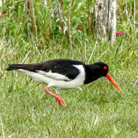
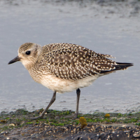
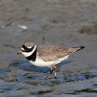
The area immediately North of the Torpoint Ferry (car/bus/pedestrian), can be divided into two distinct areas, the first is two areas of mudflats (called lakes locally) about the size of 4 football pitches at low tide and second a park area with grassland,woodland and allotments.
Detalles
Accesso
The Torpoint Ferry (technically a floating bridge) crosses the River from the City of Plymouth, on leaving the ferry there is a one way system towards the left, there is ample on street parking available. On site the start of the walk is on a raised walkway, that eventually turns to sandy and then seaweed covered rocks along Gravesend Lake/Gravesend Hard (point) and Thankes Lake, eventually you get to Thankes Park that has open grassland and woodland walks.
Terreno y habitat
Bosque , Pradera , Río , Mar , Pisos de barro , Playa , Árboles y arbustos dispersosCondiciones
Plano , Pantanoso , Rocoso , Nivel del agua alto probable , ResbaladizoCamino circular
Sí¿Se necesita telescopio?
SíBuena época para el avistamiento de aves
Todo el añoMejor momento para visitar
Invierno , Primavera , Otoño , Migración de otoño , Migración de primaveraRuta
Camino pavimentado , Camino ancho , Camino estrechoCamino difícil de andar
Caminata mediaAccesible vía
A pieEscondite de observación / plataforma
NoInformación extra
BE WARNED, after the raised walkway runs out, the remaining walk on sandy/rocky/slippery areas is below the high tide point, please check high tide times before. Plus the line of 4 STARS on map indicates the moorings (called Trots here) that are good for resting Terns.

 ) insertar los nombres de aves en tu propio idioma. ¡Los nombres de las aves serán traducidos automáticamente para otros usuarios!