
Descrizione
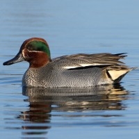
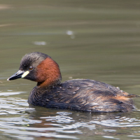
The Kievitsheide was once part of the vast Abtsheide heathlands, which covered more than 900 hectares. That was a wet heathland, which was later partly excavated for clay extraction and planted with conifers for the stone and mining industries. It is now a small-scale area with ponds and a clay pit where you can enjoy lovely walks. The clay pit and surrounding heathland attract many birds. Numerous geese and ducks can be found on the ponds.
_________________________
Nederlands: De Kievitsheide was ooit onderdeel van de uitgestrekte Abtsheide, die meer dan 900 hectare besloeg. Dat was een vochtig heidegebied, dat later deels is afgegraven voor kleiwinning en beplant met naaldhout voor de steen- en mijnindustrie. Het is nu een kleinschalig gebied met een ven en een kleiput waar je mooi kunt wandelen. De kleiput en omliggende heide zorgen voor veel vogels. Tal van ganzen en eenden terug te vinden op de waterpartijen. Bosvogels en heidevogels in het gebied erom heen.
Dettagli
Accesso
The Kievitsheide is located south of the town of Sint-Jozef (municipality of Rijkevorsel), near the Dessel–Turnhout–Schoten Canal. Entrance: Gemeentebos, 2310 Rijkevorsel. Public transport: There is a bus stop Rijkevorsel Gemeentebos on the Vlimmeren - Hoogstraten line. From this stop it is another 200 m to the entrance of the area. There is an extensive network of walking paths in the area. The circular walk shown on the map is approximately 2 km.
_________________________
Nederlands: De Kievitsheide ligt ten zuiden van de plaats Sint-Jozef (gemeente Rijkevorsel), vlakbij het Kanaal Dessel–Turnhout–Schoten. Ingang: Gemeentebos, 2310 Rijkevorsel. Er is een bushalte Rijkevorsel Gemeentebos op de lijn Vlimmeren - Hoogstraten. Vanaf die halte is het nog een 200 m tot aan de ingang van het gebied. Er is een uitgebreid netwerk van wandelpaden. De rondwandeling die is weergegeven op de kaart is ongeveer 2 km.
 ) per inserire i nomi delle specie nella tua lingua. I nomi delle specie verranno automaticamente tradotti per gli altri utenti!