


Opis
The Pišnica ('Gravelly') River forms at the confluence of Velika Pišnica (Big Pišnica) Creek and Mala Pišnica (Little Pišnica) Creek near the Kranjska Gora town. The map below covers Pišnica and Velika Pišnica valleys. At the entrance to the valley, near the confluence of two Pišnica creeks, lies Lake Jasna, which consists of two interconnected artificial lakes. The water in the river and the lakes is quite cold, even in summer (5–10 °C), as the water source is glacial, which lowers the temperature throughout the entire valley, making it more mountainous than its altitude of 800-1100 meters suggests.
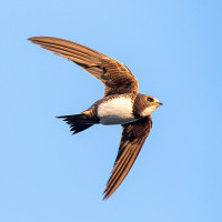
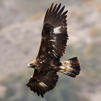
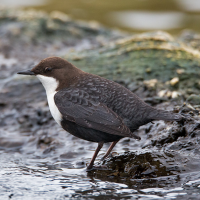
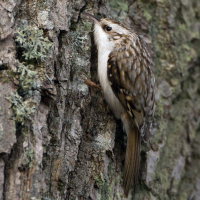
At Lake Jasna, there are mostly common bird species like krzyżówka, dymówka, oknówka, and pliszka siwa. As you progress deeper into the valley, birding gets more and more interesting, and species like sosnówka, czubatka, pełzacz leśny, pliszka górska, and pluszcz start to pop up. At the Krnica meadow, look for jerzyk alpejski. A pair of orzeł przedni probably breeds somewhere in the upper valley near the Koča v Krnici (Mountain Hut at Krnica).
The area is part of the Triglav National Park and the IBA Julijci.
Szczegóły
Dostęp
Practically the only access to Pišnica River Valley is from the Kranjska Gora town. The best place to park is at the paid parking near Lake Jasna, marked on the map below. Currently, as of writing this guide, it is also possible to park in the smaller parking 1 km further up the valley, but that parking place may be abolished soon, as it lies inside the Triglav National Park and the construction of the national park entrance barrier is ongoing.
Teren i siedlisko
Las , Góry , Dolina , Rzeka , JezioroWarunki
Górzysty , PłaskiTrasa dookoła
NieCzy luneta będzie przydatna ?
NieUdany sezon obserwacyjny
Lato , Wiosna , JesieńNajlepszy czas na wizytę
Lato , WiosnaTrasa
Droga utwardzona , Droga nieutwardzona , Wąski szlakPoziom trudności szlaku pieszego
Średnio wymagający spacerDostępne
Pieszo , RowerCzatownia/platforma obserwacyjna
NieLinki
- 'Kranjska Gora--Velika Pišnica valley' eBird hotspot
- 'Jezero Jasna | Lake Jasna' eBird hotspot
- eBird barchart of both hotspots
- IBA Julijci
 ) aby wstawić nazwy ptaków w swoim języku ojczystym. Nazwy ptaków zostaną automatycznie przetłumaczone dla innych użytkowników!