Opis
The small village of Kingsand is in South East Cornwall, but it wasn't always so, before the 1844 boundary changes Kingsand was in the County of Devon, on the wall of the Corn House in the village the boundary mark still remains today, unsurprisingly the village was known for fishing and smuggling.
This 9 km walk leaves the village Northwards, starting out crossing a section of coastal grassland with spectacular views to the East. The path continues through lightly wooded areas becoming even more wooded as you approach Mount Edgcumbe Park (see separate entry). At the parks Amphitheatre check out the pond and wander uphill amongst part of the National Camellia Collection. Continue to walk uphill and pass through the deer gate into the Deer Park, this area becomes less wooded with more open grassland (farm livestock may be present). The walk continues along the Earl's Drive passing arable farmland back to Kingsand.
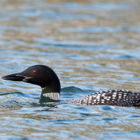
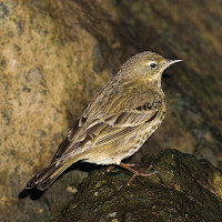
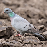
Whilst Cawsand to Penlee Battery Nature Reserve (see separate entry) can have more pelagic species and rarities it is more open and susceptible to rough seas. This walk to Mount Edgcumbe has similar land birds, but due to Plymouth Sound Breakwater the sea is more protected and some birds seek out it's calmer waters especially during more stormy conditions.
Szczegóły
Dostęp
Leave Plymouth and take car/bus/pedestrian ferry to Torpoint. Take the A374 to village of Anthony, take Left fork signed Millbrook/Seaton B3247/Whitsand Bay/Crafthole/Portwrinkle/Cawsand. At next junction turn Left signed Whitsand Bay/Cawsand/Mt Edgcumbe, continue on B3247. In town of Millbrook (road narrows) continue through town, still on B3247 turn Right at sign Rame/Cawsand/Kingsand. On arriving at Kingsand take Left turn signed Kingsand 400yds/Unsuitable For Through Traffic 7'-0" (2•1m) Wide 220 yds Ahead. BE AWARE road gets very narrow, road eventually widens, turn immediately Right into car park (Fee Payable).

 ) aby wstawić nazwy ptaków w swoim języku ojczystym. Nazwy ptaków zostaną automatycznie przetłumaczone dla innych użytkowników!